
Protect the Partrick Wetlands
and our Community
![]()
The Argument for the "No Cluster Buffer" text change to the OSRD before the Planning and Zoning Commission
Protect the Partrick Wetlands
and our Community
![]()
The Argument for the "No Cluster Buffer" text change to the OSRD before the Planning and Zoning Commission
Good Evening: Matthew Mandell w/ Bert Aber 38 Partrick Road. We share the single largest common border with the OSRD of any of the abutting neighbors to the property..
INTRODUCTION:
We are here tonight to discuss the only Open Space Residential District, the OSRD, in Westport and how we can improve on it. How we can take a zoning concept that is being emulated throughout the country and make it work better for our community and the neighborhood that surrounds it. Some of these other zoning districts are also called OSRDs while others are called CSDs (Conservation Subdivision Design). All of them differ in many ways, some are converted farmland, others in river basins, even some are along sides of mountains, but all try to protect their woodlands, wetlands, historic features, their scenic views, their community character and most of all to protect their neighbors. Most of these other OSRD regulations are newer or have been overhauled in the mid 1990's, ours has not. Ours is out of date and out of step with current thinking and lacks the new vision that planners have brought to them. It’s time to make some changes. Maybe it’s a bit late to make a giant overhaul, but it’s not to make some minor ones. What makes our OSRD the most unique, is that it is totally surrounded by established low density residential housing. Housing that has been here long before this zone was created. In our case our house has been here since 1898. It is these homes, these families, these lifestyles, these desires and expectations of consistency of neighborhood that this commission needs to protect.
PROPOSALS & HEARINGS PENDING
Now let me get something out of the way before I proceed. We are not discussing tonight whether the land itself should or should not be developed. That issue has to first be brought before Flood and Erosion and the Conservation Commission. As you know the conservation commission has already heard an application, but that decision was not accepted by the developer nor the neighbors and both have appealed to the state court. So we are at square one, with both those commissions needing to hear a new proposal. And when and if, and it is a big if, that hearings on actual development of the site come before this commission, then and only then will we be discussing that issue. ARS just this week submitted a proposal to develop the OSRD to this commission. This highly irregular move by submitting to P&Z before other commissions have even heard the proposal is a desperate attempt to thwart community wishes and to negate actions this commission might take during these hearings on the text change. Building on the this OSRD is by Special Permit which gives this commission great powers to decide what is accepted and what is denied and when. The clock is now ticking for the developer, his hand has now been played. We will proceed tonight and you will find compelling reason to adopt this text change and protect your citizens. The proposals that ARS has submitted will be used as an example of what could happen on this land, but it legally has nothing to do with the decision you make. They could just as easily submit a different proposal next week or next month. Our text change can be heard and accepted and then await what this commission will do to the ARS proposal in the coming months. By denial of special permit, or by a technicality that would force a new submission, this text change would apply.
ZONING
Tonight we will be speaking about zoning. The rules and regulations governing how a piece of land can be developed, not if or why, but how. They are a legal set of text which can be modified and improved by this commission. Improved to better suit the community and the town of Westport. I am not going to say the OSRD concept is wrong, it’s not. If this land can’t be kept as the beautiful oasis that is; if this land can’t be kept totally undeveloped as the last great piece of land in Westport that it is; and that it must be developed for who knows what reason, then an OSRD is right type of zone. The problem is this OSRD’s rules are bad. While the original framers of this zone tried to do the right thing, they failed by current standards. And Westport in turn failed when it did not follow the lead of other towns who updated or created new OSRD ordinances to protect the real useable open space and the surrounding properties.
WHAT HAVE WE PROPOSED?
We are proposing this text change to the OSRD (§17 Open Space Residential District) to protect current and future home owners, whose land is adjacent to this property, from inconsistent zoning and uncharacteristic development.
The spirit of the OSRD is to use the land efficiently by creating clustered communities within its boundaries. This text change supports this spirit while at the same time creates a buffer from said clusters, thereby protecting property values, the positive residential character, the woodland aesthetics, the lifestyles of the residents and the rustic country nature of Westport as an ongoing community. In other states towns are grappling with similar issues with their OSRDs as to how to protect sight lines, community character and property values.
There is only one OSRD in Wesport, the 55 plus acres of land between Newtown Turnpike and Partrick Road. The majority of properties surrounding this land are zoned AAA (one house per two acres) and AA (one house per one acre). The minimum spacing between these homes is 100 feet and 50 feet respectively with most exceeding that. The majority were built long before the land they abut was re-zoned. As it stands now houses within the OSRD can be 15 feet apart or less depending upon their height, which would allow an incredible 3 to 6 houses on a single acre. The current OSRD regulations permit such clusters to be located 50 feet from any neighboring property. Such encroachment on existing homes and families would ruin property values, destroy the character of the neighborhood and erode the aesthetics of the community. This is not what the framers of the OSRD intended. This is not what the residents of Westport want or deserve. It is this inconsistency of regulations that this text change attempts to address and ameliorate.
We have asked for three separate but related modifications. Allow me to go out of order here and leave the spacing issue for last, since that is really why we are here. At that time more information will be presented that will further bolster the reason for changing the other two.
17-5.1 Building Setbacks
17-5.1 Building Setbacks
No principal or accessory building, structure or use in an OSRD shall extend closer than fifty (50) ft. from any Town street line, zoning district boundary line or front, side or rear lot line. No accessory building or accessory structure for multiple or community use, such as a swimming pool, tennis court, paddle tennis court or other outdoor recreational facility located within an OSRD shall extend closer than 100 feet of any AAA and AA Zoning district boundary.
This change seeks to protect the surrounding residents of the OSRD the majority of which are AAA zoned properties and AA across the street from having to endure the noise and impact that a community use building would create, not to mention the impact on the character of the neighborhood and on property values. We are not talking about a pool for one family, or a tennis court for a couple of houses. We are talking about community use by what could be 25 houses or more and their guests. The impact is greater to the neighbors of the OSRD than it would be to neighbors of regular low density zones. The increase from 50 feet to100 feet is a reasonable amount considering the impact.
The Westport Town Planner Mary Young, let me stop here and say that Ms Young did a wonderful job with helping me get through this process and also with her analysis of my text change which was presented to the commission in the form of a memorandum dated September 6th. She expertly identified areas which most certainly should be questioned and discussed by this commission. Throughout this presentation I will address each of her concerns and also will point out where she didn’t have any. Which happens to be on this issue.
Ms Young wrote in her memo to the commission:
“An accessory building or structure for multiple or community use...could have a larger footprint than a principle use permitted in the OSRD, therefore it may be reasonable to consider establishing a special setback for this use. Additionally, an increase in setback area as proposed may provide increased privacy from noise and visual intrusion to adjoining property owners located in a Res AAA or AA district.
She does go on to discuss how “Town street line, or front and rear lot lines” etc... are not specifically addressed on this issue. First off there are no front and rear lot lines in this OSRD. The land is a blob a big one at that. 17-5.1 does have it, but the change presented is only for AAA and AA zones so having to duplicate that text seemed redundant. If this is something that has to be addressed then it would fall under what Mary smiling called a tweak.
Her next issue was whether creating increased setbacks in the OSRD would be inconsistent with the rest of the zoning regulations. But she then went on to say
“Alternatively, it can be argued that the OSRD zone is like no other zoning district, and different requirements may be applicable.”
And that is exactly the point. There are multiple PRDs which is the most similar zoning district and they are small compared to the OSRD and could not sustain these greater setbacks feasibly. Also their location is primarily on the Post Road, a commercial area where as the OSRD is completely surrounded by low density residential AAA and AA properties. And there is only one OSRD and no more are going to be created. At least none with this text. As I said before new OSRD zoning regulations around the country are far more dedicated to protection not just of the open space, but of the surrounding community. But let’s save this for later.
17-17.1 Road/Recreation Buffer
17-17.1 Road/Recreation Buffer
Any internal perimeter road or accessory structure for multiple or community use, such as a swimming pool, tennis court, paddle tennis court or other outdoor recreational facility located within 200 feet of any Residence AAA or AA Zoning District boundary line, or within 100 feet of any Residence [AAA, AA,] A or B Zoning District boundary line shall include evergreen plantings, mounds, berms, walls, fences or other similar devices or combinations there of, of a location, type, materials, height, spacing, arrangement and design that will screen the activity, noise or facility on the lot from a neighboring single -family residential area.
This one is quite simple. All that we have asked for is greater green buffering than currently exists. As Ms. Young notes and the text of the section states, there already is a requirement to create a buffer of plants etc within 100. We think that 200 feet would be reasonable considering the possible size of the development and the impact on the character of the community and on property values.
Ms. Young again brings up the possible inconsistency issue, but again she says “ it can be argued that the OSRD zone is like no other zoning district, and different requirements may be applicable.” We would concur and again say this is the only OSRD and no other zoning district could sustain it nor would merit it.
SPACING
So now we have to come to the big issue. The one that we are all here to discuss, debate and decide upon. The issue that is at the heart of this text change. The idea that a “No Cluster Buffer” should be implemented through the use of greater separation of homes within 200 feet of any AAA or AA zone. Again, this is not a no build zone, it is a lower density zone, a transition from traditional lots to the clusters within the OSRD.
17-9 Building Spacing
17-9 Building Spacing
Groups of buildings on a single lot shall be so arranged that the minimum horizontal distance between the nearest walls or corners of any principal and/or accessory detached buildings shall not be less than one-half (1/2) the sum of the height of such adjacent buildings. Buildings within two hundred (200) feet from any AAA or AA Zoning District boundary line shall have a minimum horizontal distance between the nearest walls or corners of any other principal and/or accessory detached buildings of not less than eighty (80) feet.
Let’s look at the map, which the P&Z department along with the Conservation department put together. Again for purposes of clarity, this is just an example of what can be built. This proposal is no longer valid, but essentially shows what could happen. Who really knows what proposal, if any, that this commission will finally see. There are many hearings to come before then.
Map Discussion.
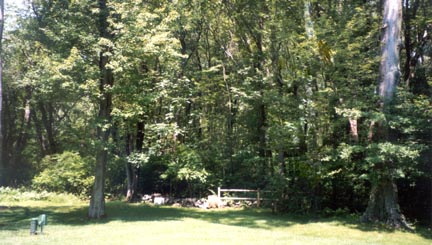
Now please let’s look at the photo pages in the packet. They are after all the letters of support our neighbors and this community has submitted in favor of this text change and this is addition to those who are here ready to speak.
They say a picture is worth a thousand words. The first picture is from our backyard taken east towards the OSRD. The second is what these two houses would look like after they are built.
Photo Discussion.
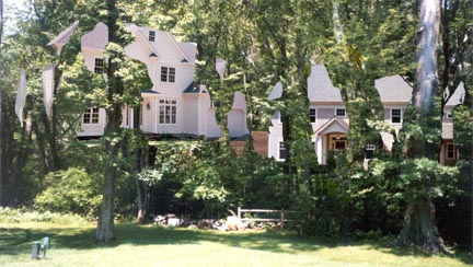
Aber Backyard after Proposed Cluster is built (artist rendition, based on proposal)
So why am I here in front of you? Because when I first visualized how a developer could manipulate this OSRD’s rules to create the monstrosity that you are now looking at, I knew I had problem on my hands, my neighborhood had a problem on its hands, Westport had a problem on its hands.
What will this text change do?
Remove clusters from the perimeter, while still allowing them to exist in the interior so the spirit and positive attributes of the OSRD can be fulfilled.
What will this text change accomplish?
1. Protect the Character and lifestyles of the neighborhood.
2. Protect the property values of the neighboring families.
3. Further protect the wetlands and open space due to that many fewer homes.
4. Observable over-development will be minimized.
5. Privacy and the woodland aesthetics of all the properties will be enhanced.
6. Allow for in-character houses to be built which would be worth more to the developer and potential buyer and in turn the neighbors in value and aesthetics.
All of these issues weave back and forth on each other so as I speak I will make reference to these ideas as they come about.
Lets start with what our OSRD’s intent is by looking at its purpose.
Westport OSRD 17-1 Purpose
...It is in the public interest to preserve the residential character of Westport, to provide a desirable alternative to presently permitted commercial uses in specific locations, to reduce the potential traffic and drainage impacts on public facilities, and to provide a better layout and design of housing in environmentally sensitive areas. The OSRD can help to achieve these objectives.
Well does it seem to you by looking at this map or the pictures you have in front of you that this zoning regulation is achieving its purpose? NO!!!.
The country character of our community is what brought so many people to Westport. That character is completely in jeopardy as multiple homes clustered tightly together will be foisted upon a neighborhood that doesn’t want them and was never given a chance to work out a solution.
All the homes in the area are on 1 or 2 acre plots and spaced apart reasonably. There is a country feel to the properties of Partrick Rd, Crawford, Newtown, Lowlyn and Oakwood. Suddenly having clusters right in view of current homes and from the road destroys the very reason people enjoy Westport. The intrinsic value and the enjoyment of having woods and greenery all around will be gone and in its place will be left over-development. Why, because the OSRD as it stands now can’t prevent it. So how do we rectify this inadequacy?
Randell Arendt the noted expert on OSRDs having written numerous books on the subject and designed dozens of OSRDs says in his paper Open Space Zoning, What is it Why it Works:
“Will It Harmonize With Its Surroundings? A concern I often hear is that cluster housing will not blend in with a town's rural character. It is true that some cluster developments done in the past have failed to harmonize with their surroundings. Recognizing this potential problem, a few communities are now requiring that new cluster plans consist of only detached, single family homes, each set on its own, down-sized individual lot, roughly resembling a traditional village pattern. This also ensures that everyone will have their own separate yard space, in addition to the larger "open space" which the cluster approach creates.”
So Arendt agrees that having a single house on its own lot to blend in with the community in addition to having clusters is the most feasible way to deal with this situation.
Now how do you create this? With a “NO CLUSTER BUFFER” The one I have proposed and the one that the South Western Regional Planning Agency in a meeting they held on Sept 9, agrees with. And they said this.
SWRPA supports the proposed amendments to the Open Space Residential District regualtions. The intent of the OSRD regulations is to allow for flexibility in the residential lot design based on the natural features of the setting. The proposed amendments affect the “transitional/buffer” area between the conventional large lot residential development and the clustered housing concept used for the OSRD.”
We are not just about talking regular people here but planners who this commission went to, to seek their opinion.
Arendt continues in the same article.
The related issue of "impact upon surrounding property values" is also often raised. Along any part of the parcel perimeter where down-sized lots would adjoin standard-sized lots, communities can require buffer strips. Along other edges, this may not be desirable or logical, as lots which border permanently protected open space almost always enjoy higher property values. Indeed, most realtors would attest to the fact that all lots within a well-designed cluster development usually gain enhanced value as a result of the protected open space.
This quote has two great issues in it. One of the buffer strip, that it is totally reasonable to have one to protect the abutting neighbors from the clusters and two that properties next to permanent open space increase in value. So what’s good for the goose is good for the gander. Less houses next to any of ours, leaving permanent open space instead would increase our values. Same would be true of the single houses in the no cluster zone. And one could extrapolate that if there were two houses next to us instead of open space our property value would not be enhanced.
Let’s stay with property values which essentially brings the character of the neighborhood with it. Since we are talking about only single houses within anyone’s view shed this would keep the character of the neighborhood intact.
Edward McMahon a noted land use planner, attorney and author said in his “Green Enhances Growth” article:
“a 1995 survey conducted for a group of the nation's largest volume homebuilders by American Lives... says that the results show that "consumers are putting an increasingly high premium on interaction with the outdoor environment through the inclusion of wooded tracts, nature paths, and even wilderness areas in housing developments." In fact, 77 percent of consumers put "natural open space" as the feature they desired most in a new home.”
Two houses across the street with no open space, doesn’t sound too good. One house across from you, in-character with the neighborhood with open space and people will come.
The Town of Cary’s Open Space and Historic Resources Plan continues:
“Confirming this trend, Realen Homes found that lots adjacent to open space sold faster than other lots despite their premium prices.”
Again, put two houses next to our back yard and we lose the open space that people so desperately want.
Arendt concludes in his article “Growing Greener:”
“Homebuyer surveys show that people strongly desire open space, recreation areas, and scenic views.”
Putting clusters right up against the road across the street from AA zoning and next to abutting AAA homes is not fair. Only the houses within the OSRD will have the open space thus sacrificing of those who currently live in the area. The whole feel to the neighborhood will be lost at the expense of those live there. The OSRD is flawed and needs to be adjusted.
What the hey one more quote before I move on.
Elizabeth Brabec who specializes in developing resource conservation strategies and is also an Associate Professor at the University of Michigan School of Natural Resources and Environment. Writes in “On the Value of Trees and Open Space”
“Trees not only affect our living environment, but also have a direct impact on the value of our homes. Numerous studies have shown that people are willing to pay more for homes that are surrounded by trees... How much more? Depending on the area of the country, anywhere from 3 to 18 percent. Even those studies that did not attempt to quantify the increase in value have found that the decision to buy a particular house was often swayed by the presence of trees.”
Trees - Houses - Trees - Houses. Two Houses in your back yard or one house with trees. It’s a no brainer. The in- character low density choice is obvious. And a buffer of some extra trees is not going cut it. The houses will be there, everyone will know it. And don’t forget that the single house inside the zone will benefit just as well. It’s a win - win situation.
So have I accomplished my goals?
1. Protect the Character and lifestyles of the neighborhood.
2. Protect the property values of the neighboring families.
3. Further protect the wetlands and open space due to that many fewer homes.
4. Observable over-development will be minimized.
5. Privacy and the woodland aesthetics of all the properties will be enhanced.
6. Allow for in-character houses to be built which would be worth more to the developer and buyer and the neighbors in value and aesthetics
HOW DO OTHER OSRD’s WORK?
Most current OSRDs try to work with the local community as well as protect important areas
Arendt continues:
”The next task is to identify two kinds of resource areas. Primary Conservation Areas comprise only the most severely constrained lands, where development is typically restricted under current codes and laws (such as wetlands, floodplains, and slopes exceeding 25%). Secondary Conservation Areas include all other locally noteworthy or significant features of the natural or cultural landscape-such as mature woodlands, wildlife habitats and travel corridors, prime farmland, groundwater recharge areas, greenways and trails, river and stream corridors, historic sites and buildings, and scenic viewsheds. These Secondary Conservation Areas are often best understood by the local residents who may be directly involved in their identification.”
This is wonderful, except our OSRD never allowed for local resident input. And the current developers certainly didn’t. They said, this is what we are going to do. We have a piece of upland and we are going to build on it even if we need a shoe horn. Who cares if it destroys your view shed.
Gloucester MA’s OSRD tries to protect neighbors and is flexible.
Gloucester Planning Board Open Space Design Initiative:
“Plan 2001, in the Land Use section, calls for policies to protect the quality of life and environmental and visual assets, to increase the supply and decrease the cost of housing... Similarly, the Open Space section of the plan calls for process to set priorities for the preservation and protection of private and public open space. Open space design, also known as conservation subdivision design, is a tool for achieving these goals.
The open space residential/subdivision design permitting process is a flexible planning tool which would allow Gloucester to meet both its development and conservation goals. It provides a process of working with all interested parties, in the pre-application stage of a land use proposal, to identify special features of a site and cooperatively plan and direct development to other locations on-site.
Our OSRD doesn’t have a pre-application process. And as an interested party I didn’t work through the process. And things I want moved are still right where they are.
In Upton MA their OSRD tries to preserve the New England character according to Tim Puriton form the Mass Audubon Society.
“It's more than looking at a plot plan with delineated wetlands and laying down house lot lines.... It's walking the property and visualizing how houses can harmonize with their surroundings. It's about preserving views, stonewalls, forests, fields and distinctive trees, not only in the open space, but in the developed area, as well, when possible. It's about preserving New England's community character. “
Almost makes you wonder why we live in Westport and not in Upton MA.
Let me change states for a moment.
In Pennsylvania, Lower Providence’s OSRD requires that there is a preliminary plan submitted before anything begins, but most interesting is in that plan they requires information about what extends beyond the OSRD tract for 200 feet. This way when they design their project they can take into account what is there, who is there and what their needs might be.
Lower Providence Township
§ 123-18. Preliminary plan submission requirements.
Preliminary plans shall be submitted for all proposed subdivisions and land developments not eligible for submission as a minor subdivision or a minor land development.
A. Contents of preliminary plans. Preliminary plans shall provide the required information as described in § 123-14, and, in addition, land developments shall provide the information required in § 123-16 of this article. In addition, preliminary plans shall provide the information below:
(1) Existing features outside the tract. For a distance of 200 feet outside the boundary of the tract being subdivided or developed
Other towns allow for distinctive setbacks based on density of zones. Exactly what I have submitted here and exactly what the Greater Bridgeport Regional Planning Agency voted to support. Another group of planners this commission sought out for comment.
Our neighbors in Norwalk use different setbacks specifically with their conservation development areas. By their using special standards when it comes to lower density zones, this should allay any of your fears that my multiple standards based on density zones is unique, its not and is perfectly reasonable.
Artice 41 C. Additional standards for conservation developments. Conservation developments shall be subject to the following additional standards
(1) No main building shall be nearer to any other main building than forty (40) feet in a AAA Zone thirty feet (30) in a AA zone and twenty feet (20) in the A Zone
Oshtemo Michigan does it too.
60.520 Open Space Community - Scope (second paragraph)
An Open Space Community shall be recognized as a Special Exception Use and shall be controlled by the guidelines thereof. Such residential developments shall be permitted as a Special Exception Use in the "AG", "R-1" "RR", "R-2", "R-3", "R-4" and "R-5" Zoning classifications.
64.750(a)-(c) Supplemental setback provisions for property abutting a higher [classification]
(a) 50 feet where the subject site is in a "R-3", "R-4" or "R-5" zoning classification and abuts property in an "AG" "RR", "R-1" "R-2" zoning . . . .
(b) 85 feet where the subject site is in a "C", "C-1", or "C-R" zoning classification and abuts property in an "AG", "RR", "R-1","R-2" . . . .
(c) 100 feet where the subject site is in an "I-R", "I-1", "I-2", or "I-3" zoning classification and abuts property in an "AG", "RR", "R-1", "R-2" . . . .
And this one is a really wonderful. Branford CT’s OSRD allows for modification of setbacks when character is involved.
34.2 Purpose: The Commission may approve a SPECIAL EXCEPTION to permit establishment of an Open Space Residential Development Plan involving modification of lot area, shape and setback requirements if it finds that the SPECIAL EXCEPTION will accomplish one or more of the following purposes:
34.2.1 To permit tracts of considerable size in Residence R-3, R-4 and R-5 Districts to be designed and developed for single family residential and similar purposes in such manner as to accomplish one or more of the following open space purposes:
a. To preserve land as unsubdivided and undeveloped open space which preserves or enhances the appearance, character and natural beauty of an area;
Boston OSDR specifically protects views
OSRD OR CONSERVATION SUBDIVISION DESIGN (CSD) MODEL BYLAW
Produced by the Metropolitan Area Planning Council Boston, Massachusetts August 2000
“The design process makes the placement of house lots and streets sensitive to this objective. The design process identifies historical, cultural and natural resources, potential open space corridors [and] views, etc. that should be preserved. This process excludes these areas from development and targets construction on the rest of the parcel.”
All these OSRDs do what ours does not. They protect views, they protect their neighbors, they allow for community input. It is too late to change our entire OSRD, but this little text change can go a long way to salve the wound.
Memorandum:
So let me get back to Mary Young’s comments and finish up.
She notes on page 6 that “setbacks not building spacing are the tool used to buffer residents from one another.” She is right, but the setbacks work for only one house. Not the second or the third or the fourth. Only spacing the houses farther apart in the “No Cluster Zone” will accomplish the desired effect. The OSRD has spacing requirements already as part of it rules, so it is an easy modification. A reasonable modification.
Also on page 6 she brings in the conservation commission’s comment about 8 houses being affected. 8 affected, but not eliminated. It would be up the developer to move houses about to see how many could still be proposed. Also since there is a new hearing to be scheduled for conservation leaves the argument that adoption of this text would force a new hearing moot. We are at square one with this whole deal.
On page 7 Ms Young discusses the purpose of the OSRD, its clustering concept and the uses of the land.
1. Clustering would still occur, but not near the perimeters. So its purpose would still be fulfilled.
2. There is no recreation to be created on this land because there will be no access to it. You don’t know this yet, but ARS could not give this land away. And said they’d bar access to it. Also this change does not affect recreation.
3. There is no open common space, other than the mandated 75' diameter circle. Now if that is not a flaw in the regulations, I don’t know what is.
4. As for environmentally sensitive areas, this text change would help by removing a few houses.
On page 8 Ms Young wonders whether these more restrictive setbacks and landscaping requirements won’t bring a slew of similar applications. And that the commission would have to justify their position. Again there is only one OSRD and it is like no other zone in a location like no other. I don’t believe there will be a problem and justification would be easy.
Lastly she brings up the possible peace meal changing of regulations. This is only because last week a developer was arguing for a change to section 19 of the zoning code for his own benefit. This change is for the good of an entire neighborhood in a zoning district that is completely unique. And the changes are use the words and spirit already in the regulations.
READ LETTERS
SUMMATION
The OSRD regulations do not protect the very neighbors it should protect those living around the property. This text change gives the protection they deserve from unneeded and unnecessary encroachment and development.
We have not asked for the world here. We did not asked for a no build zone of 200' we did not ask for spacing of 100 feet. We are asking for what is reasonable and it should be granted.
Essentially if there was time or a way for this commission to use its power utilizing the Special Permit part of this ordinance and then review the entire OSRD regulation and overhaul it, bringing it into the 21st century, I’d say that would be the best thing to do. But barring that, this text gives relief to where it is need most, on the perimeter to those who abut it and live near it.
Thank you.
APPENDIX
Letters from Westport Citizens in support of the Change
Pictures
Regional Planning Agency letters.